The Ultimate Manang SUV Tour offers adventure seekers and mountain enthusiasts the perfect way to explore Nepal's stunning Annapurna region without the physical demands of traditional trekking. This comprehensive guide is designed for travelers who want the thrill of high-altitude adventure combined with the comfort and convenience of vehicle-based exploration.
This guide covers everything you need to plan your Manang SUV adventure successfully. You'll discover how to choose the best routes and optimize your itinerary to maximize your mountain views and cultural encounters. We'll also walk you through the essential gear you need to pack for high-altitude conditions and unpredictable weather.
From finding the right accommodations in remote mountain villages to understanding local customs and safety protocols, this guide gives you the practical information to make your Manang SUV tour both memorable and safe.
Planning Your Manang SUV Adventure
Best Time to Visit for Optimal Weather Conditions
The sweet spot for your Manang SUV adventure falls between October and December, when clear blue skies dominate and daytime temperatures remain comfortable. During these months, you'll experience crisp mountain air with daytime temperatures ranging from 10-15°C at lower elevations, dropping to around 0°C at night in Manang village.
Spring months (March to May) offer another excellent window, with rhododendrons blooming across the hillsides and gradually warming temperatures. However, afternoon clouds can build up, potentially obscuring mountain views.
Avoid the monsoon season (June to September) at all costs. Heavy rains turn mountain roads into muddy nightmares, triggering landslides that can leave you stranded for days. The winter months (January to February) bring extreme cold and snow that can completely block high-altitude passes.
Weather patterns change rapidly in the mountains. Even during optimal seasons, pack layers for temperature swings of 20°C or more between day and night. Morning starts often require thermal wear, while afternoons might have you in t-shirts.
Essential Documents and Permits Required
Your adventure requires specific paperwork that you cannot skip. The Annapurna Conservation Area Permit (ACAP) costs NPR 3,000 for foreigners and serves as your entry ticket to the region. Obtain this through the Nepal Tourism Board office in Kathmandu or Pokhara.
The Trekkers' Information Management System (TIMS) card adds another NPR 2,000 to your budget. This blue card tracks trekker movements and proves invaluable during emergencies. Both permits require passport photos and copies of your passport's main page.
Your SUV driver needs a valid Nepalese driving license specifically endorsed for tourist vehicle operations. International driving permits don't work here. Vehicle registration documents and insurance papers must accompany your journey.
Keep multiple photocopies of all documents in waterproof bags. Checkpoints appear regularly along the route, and losing permits halfway through means expensive return trips to Kathmandu or potential fines.
| Document | Cost (NPR) | Where to Obtain |
| ACAP Permit | 3,000 | Nepal Tourism Board |
| TIMS Card | 2,000 | Nepal Tourism Board |
| Driver License | Variable | Department of Transport |
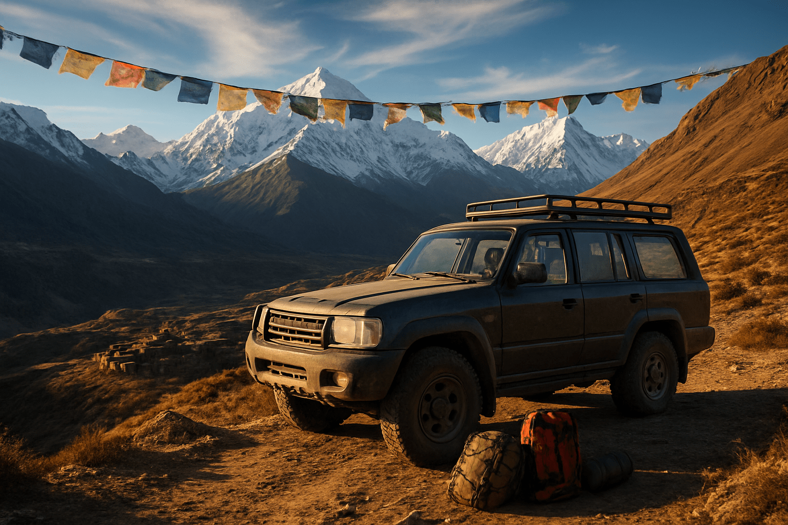
Choosing the Right SUV for Mountain Terrain
Mountain roads demand serious vehicle capabilities. Your SUV needs four-wheel drive as standard equipment, not an optional extra. The Mahindra Scorpio and Toyota Land Cruiser dominate these routes for good reason - proven reliability and local mechanic familiarity.
Ground clearance matters more than horsepower. Aim for a minimum of 200mm clearance to navigate rocky sections and water crossings. Smaller crossovers might look capable but lack the structural strength for sustained rough road punishment.
Diesel engines outperform petrol alternatives at high altitudes where oxygen levels drop significantly. Turbo-diesel systems maintain power better above 3,000 meters of elevation. Manual transmissions give you better control on steep descents and help prevent brake overheating.
Tire condition determines your safety margin. Inspect tread depth carefully and insist on matching brands across all four wheels. Carry two spare tires minimum - rocky terrain destroys rubber quickly. All-terrain tires provide the best compromise between road comfort and off-road grip.
Vehicle age impacts reliability dramatically. Choose SUVs under five years old with documented service histories. Older vehicles might seem economical, but breakdowns in remote areas cost far more than rental savings.
Budget Breakdown for Complete Trip Costs
A well-planned Manang SUV adventure typically runs NPR 80,000-120,000 ($600-900) for a group of four people over 7-10 days. This covers all major expenses but excludes personal shopping and alcohol.
Vehicle rental dominates your budget at NPR 8,000-12,000 daily, depending on SUV type and season. Peak season rates (October-November) command premium pricing. Include fuel costs of approximately NPR 15,000 for the complete circuit.
Accommodation ranges from basic teahouses at NPR 500-800 per person nightly to comfortable lodges charging NPR 2,000-3,000. Food costs average NPR 800-1,200 per person daily, with prices increasing significantly above 3,500 meters elevation.
| Expense Category | Daily Cost (NPR) | Total Trip Cost (NPR) |
| SUV Rental | 10,000 | 80,000 |
| Fuel | 2,000 | 16,000 |
| Accommodation | 2,000 | 16,000 |
| Meals | 3,200 | 25,600 |
| Permits | - | 5,000 |
Emergency funds deserve serious consideration. Keep NPR 20,000-30,000 accessible for unexpected expenses like vehicle repairs, weather delays, or medical evacuations. Mountain regions don't accept credit cards reliably, making cash king for all transactions.
Route Selection and Itinerary Optimization
Classic Manang Circuit via Besisahar
The traditional approach to Manang begins at Besisahar, offering the most comprehensive experience of the Annapurna Circuit's diverse landscapes. This route starts with lush subtropical forests and terraced fields before climbing through rhododendron forests into alpine terrain. The journey typically spans 7-10 days, allowing your body to acclimatize naturally to increasing altitudes.
From Besisahar, you'll drive to Chame, the district headquarters of Manang, passing through dramatic river valleys and experiencing the gradual shift from Hindu to Tibetan Buddhist culture. The road winds alongside the Marsyangdi River, revealing spectacular mountain vistas as you ascend. Key stops include Tal, where waterfalls cascade directly onto the trail, and Bagarchhap with its traditional stone houses and prayer wheels.
The final stretch from Chame to Manang village presents breathtaking views of Annapurna II, III, and IV, along with Gangapurna. This section requires careful pacing, as you'll gain significant elevation over relatively short distances. The route passes through Pisang, where you can choose between upper and lower trails, each offering unique perspectives of the surrounding peaks.
| Daily Stages | Distance | Driving Time | Altitude Gain |
| Besisahar to Tal | 45 km | 3-4 hours | 800m |
| Tal to Chame | 35 km | 2-3 hours | 700m |
| Chame to Pisang | 25 km | 2 hours | 500m |
| Pisang to Manang | 20 km | 1.5 hours | 300m |
Alternative Routes Through Thorong La Pass
Several alternative approaches can enhance your Manang experience, particularly if you're combining it with other destinations or seeking different perspectives. The Thorong La Pass route offers a challenging but rewarding approach from the west, connecting Manang with the Mustang region.
Starting from Muktinath, this route reverses the traditional circuit direction, providing unique photographic opportunities and fewer crowds during certain seasons. The drive from Muktinath to Manang via Thorong La Pass (when accessible by vehicle) offers dramatic high-altitude desert landscapes and panoramic mountain views that differ significantly from the eastern approach.
Another compelling option involves the Nar Phu Valley extension, adding remote villages and restricted area permits to your journey. This route branches off from Koto, just before Manang, leading to ancient settlements that receive few visitors. The return journey reconnects with the main route, allowing you to experience both the classic circuit and hidden gems.
For those with limited time, the direct helicopter route to Manang provides immediate access to high altitude, though this approach requires extra acclimatization days and careful monitoring of altitude sickness symptoms.
Alternative Route Options:
- Muktinath to Manang (reverse circuit)
- Nar Phu Valley extension
- Helicopter access with extended acclimatization
- Tilicho Lake side trip integration
Daily Distance Planning and Rest Stops
Smart distance planning makes the difference between an enjoyable journey and a grueling ordeal. Plan daily driving segments between 3-5 hours maximum, accounting for road conditions, weather delays, and photography stops. High-altitude driving demands frequent breaks every 45-60 minutes to prevent driver fatigue and allow passengers to adjust to elevation changes.
Strategic rest stops serve multiple purposes beyond simple breaks. Plan stops at teahouses in Dharapani, Chame, and Pisang for meals, bathroom breaks, and interaction with locals. These stops also provide backup accommodation options if weather or vehicle issues force schedule changes.
Consider overnight stops in Chame or Pisang rather than pushing straight through to Manang in one day. This approach allows better acclimatization and reduces the risk of altitude-related issues. The extra day also provides flexibility for side trips to nearby gompas (monasteries) or short hikes to viewpoints.
Build buffer time into your itinerary for common delays: landslides during monsoon season, mechanical issues on rough roads, and permit checking at various checkpoints. Local festivals or market days can also affect road conditions and accommodation availability.
Essential Rest Stop Schedule:
- Every 45-60 minutes for driver rotation and passenger comfort
- Meal stops at established teahouses with clean facilities
- Photography stops at major viewpoints (budget 30-45 minutes each)
- Overnight acclimatization stops before reaching maximum altitude
- Emergency shelter identification at regular intervals along the route
Essential Gear and Packing Checklist
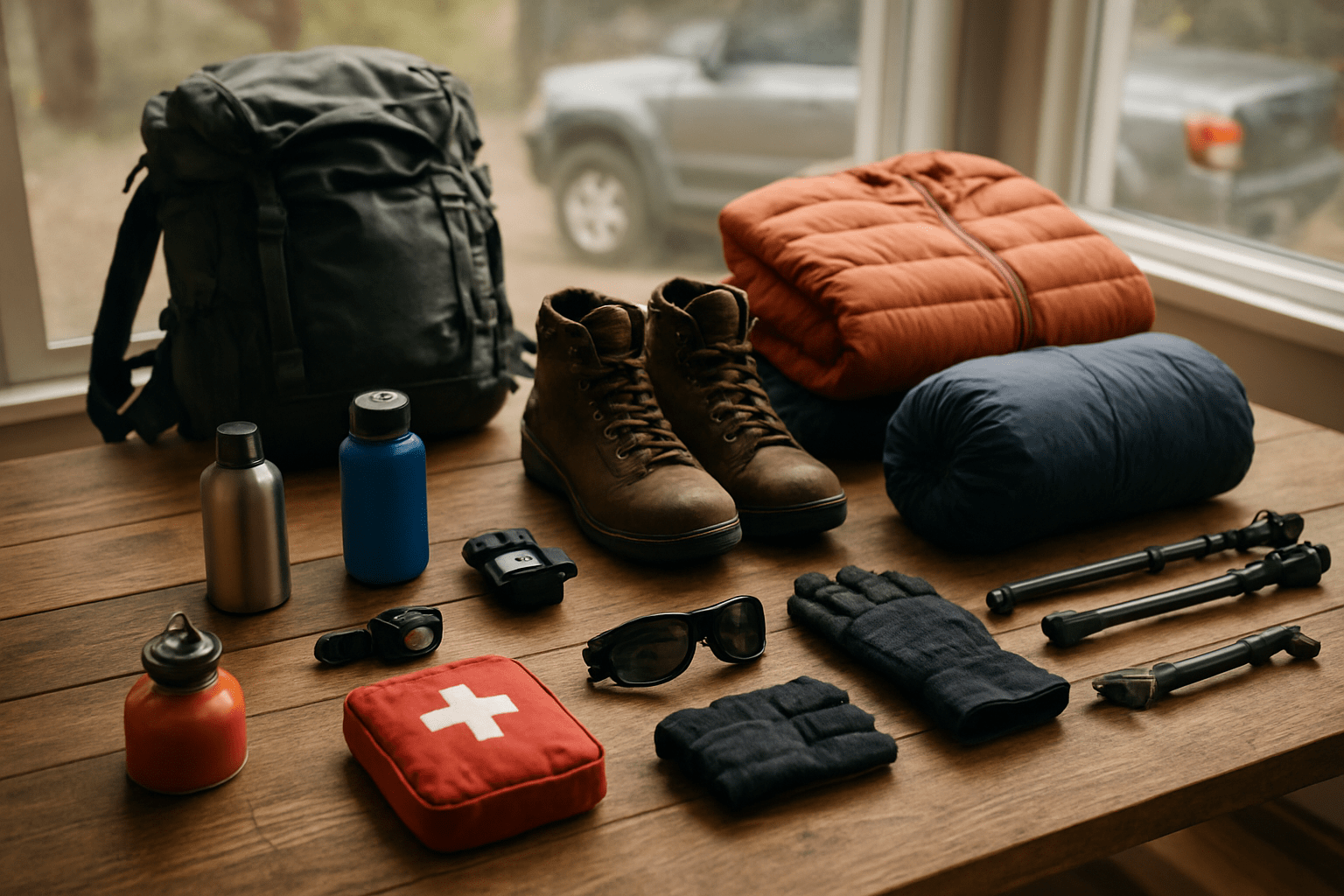
High-Altitude Clothing Requirements
The Manang region sits at elevations between 3,500 and 4,500 meters, where temperatures can swing dramatically from pleasant daytime conditions to bone-chilling nights below freezing. Your clothing system needs to handle these extremes while keeping you dry and comfortable.
Start with a solid base layer system using merino wool or synthetic materials that wick moisture away from your skin. Pack at least three sets - you'll be grateful for dry backup layers when the first ones get soaked from snow or sweat. Skip cotton entirely, as it becomes deadly when wet at altitude.
Your insulation layer should include a lightweight down jacket rated for temperatures down to -10°C. A fleece or synthetic insulated jacket works as a backup and performs better when damp. For your lower body, pack insulated pants or thick trekking pants with thermal leggings underneath.
The outer shell layer protects against wind and precipitation. Choose a waterproof, breathable jacket and pants with full-zip ventilation. Mountain weather changes fast, and you need gear that adapts quickly.
Don't forget extremities - they're most vulnerable to frostbite. Bring two pairs of insulated gloves (liner gloves plus waterproof outer gloves), a warm beanie, a sun hat, and glacier glasses. Pack gaiters to keep snow out of your boots, and consider bringing lightweight camp shoes for evenings in lodges.
Emergency Medical and Safety Equipment
High-altitude SUV tours present unique medical risks that require specific preparation. Altitude sickness affects most travelers above 3,000 meters, making prevention and treatment supplies critical for your safety.
Pack acetazolamide (Diamox) for altitude sickness prevention, but consult your doctor before departure about proper dosage and timing. Include ibuprofen for headaches, anti-nausea medication, and oral rehydration salts for dehydration. A pulse oximeter helps monitor your oxygen saturation levels - readings below 85% at rest require immediate descent.
Your first aid kit should contain sterile gauze, medical tape, antiseptic wipes, blister treatment, and elastic bandages. Add a digital thermometer, tweezers, and scissors. Include any personal prescription medications with extra supplies in case of delays.
Safety equipment starts with a reliable headlamp and backup batteries - mountain weather can create whiteout conditions even during daytime. Pack an emergency shelter like a bivy sack or emergency blanket, plus waterproof matches and a fire starter. A whistle provides signaling capability if separated from your group.
Communication devices save lives in emergencies. Satellite communicators or GPS messengers work where cell phones fail. Download offline maps to your phone and carry a physical map as backup. Consider renting or purchasing a portable oxygen canister for severe altitude emergencies.
Photography and Documentation Tools
The Manang region offers spectacular mountain vistas, ancient monasteries, and unique cultural scenes that demand proper documentation equipment. Cold temperatures, altitude, and dust create challenging conditions for photography gear.
Digital cameras perform better than film at altitude, but batteries drain faster in cold conditions. Pack extra batteries and keep them warm in inside pockets. Memory cards can fail, so bring multiple cards and back up your photos regularly. A portable power bank designed for cold weather extends your shooting capability.
Lens selection depends on your priorities. A versatile zoom lens (24-70mm equivalent) handles most situations, while a telephoto lens (70-200mm) captures distant peaks and wildlife. Wide-angle lenses showcase dramatic landscapes. Protect lenses with UV filters and cleaning supplies - mountain dust gets everywhere.
Tripods stabilize shots in low light conditions, common during sunrise and sunset golden hours. Carbon fiber tripods weigh less and handle temperature changes better than aluminum. Remote shutter releases or intervalometers enable self-portraits and time-lapse photography.
Action cameras document the journey itself, mounting easily inside vehicles or on gear. Waterproof cases protect against snow and rain. Drone photography captures unique perspectives, but check local regulations and respect cultural sensitivities around monasteries.
Store equipment in padded camera bags with weather protection. Silica gel packets absorb moisture that can damage electronics. Clean gear daily to prevent dust buildup.
Food and Water Storage Solutions
Self-sufficiency in food and water becomes critical during multi-day Manang SUV expeditions, especially when weather delays separate you from planned meal stops or lodge accommodations.
Water storage starts with multiple containers - rigid bottles for daily use and collapsible reservoirs for bulk storage. Insulated bottles prevent freezing, while wide-mouth designs make refilling easier with gloves on. Plan for 3-4 liters per person daily at altitude, where dehydration happens faster due to increased respiration and dry air.
Water purification requires redundant systems. UV sterilizers work quickly but need battery power. Pump filters remove sediment and bacteria, but may freeze. Water purification tablets serve as a reliable backup. Boiling water remains foolproof but requires fuel and time.
Food planning balances nutrition, weight, and preparation simplicity. High-calorie foods provide energy for altitude adaptation and cold weather. Nuts, dried fruits, and energy bars offer quick fuel. Instant meals requiring only hot water work well - oatmeal, soup mixes, and freeze-dried entrees.
Cooking equipment should include a reliable stove that functions at altitude and cold temperatures. Canister stoves perform wel,l but gas pressure drops in cold conditions. Liquid fuel stoves work more reliably but require more maintenance. Pack extra fuel - altitude increases consumption.
Food storage containers must be waterproof and rodent-proof. Bear canisters work well, or use multiple smaller containers to distribute weight and reduce loss if one fails. Insulated food containers keep meals warm longer in cold conditions.
Accommodation and Dining Options
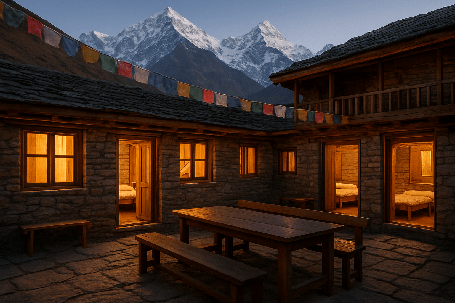
Tea House Bookings Along the Route
The Annapurna Circuit features a well-established network of tea houses that serve as lifelines for trekkers making their way to Manang. These family-run lodges offer basic but comfortable accommodation with shared bathrooms, communal dining areas, and spectacular mountain views. Peak seasons from October to November and March to May fill up quickly, so booking through local agents or online platforms becomes essential.
Most tea houses charge between $5-15 per night for a basic room, with prices increasing as you gain altitude. Manang village itself hosts several quality options, including Hotel Manang and Tilicho Hotel, which offer private bathrooms and Wi-Fi connectivity. The Himalayan Hotel provides stunning glacier views and serves as an excellent acclimatization base.
Booking strategies vary depending on your flexibility. Independent travelers can walk in during off-season months, but group bookings require coordination 2-3 weeks ahead. Many tea houses accept advance payments through local trekking agencies in Kathmandu or Pokhara, which also handle itinerary changes due to weather delays.
Camping Equipment for Remote Areas
Venturing beyond established tea house routes demands self-sufficiency and quality camping gear suited for high-altitude conditions. Temperatures can plummet to -20°C during winter months, making a four-season tent with robust wind resistance absolutely critical. Look for models with aluminum poles and reinforced guy-lines that can handle sudden weather changes common in the Himalayas.
Your sleeping system requires careful consideration - a sleeping bag rated for -15°C minimum, paired with an insulated sleeping pad with R-value above 4, prevents heat loss to frozen ground. Portable stoves must function reliably at altitude, where oxygen levels drop significantly. Jetboil or MSR models with windshields perform consistently in harsh conditions.
Water purification becomes crucial in remote areas where natural sources may carry contaminants. Portable filters like LifeStraw or SteriPEN eliminate bacteria and viruses effectively. Pack extra fuel canisters since resupply options disappear beyond main villages, and always carry backup lighting and navigation tools for emergencies.
Local Food Specialties to Experience
Manang's unique location at the crossroads of Tibetan and Nepali cultures creates a distinctive culinary landscape that reflects centuries of trade route influence. Dal bhat remains the staple meal throughout the region - a hearty combination of lentil soup, rice, and seasonal vegetables that provides sustained energy for high-altitude activities. Local variations include buckwheat and barley preparations that grow well in the harsh mountain climate.
Tibetan-influenced dishes dominate higher elevations, with thukpa (noodle soup) warming trekkers during cold mountain evenings. This rich broth combines vegetables, yak meat, and handmade noodles in a satisfying meal that aids acclimatization. Momos, steamed dumplings filled with vegetables or meat, appear on most tea house menus and make excellent lunch options during long trekking days.
Yak cheese products represent authentic regional specialties worth trying despite their strong flavors. Local bakeries in Manang village produce Tibetan bread and apple pies using ingredients grown in nearby orchards. Chang, a traditional fermented barley beverage, offers cultural insight but should be consumed moderately at altitude. Tea houses serve butter tea (po cha) - a salty, creamy drink that helps prevent dehydration and provides calories needed for mountain activities.
Safety Protocols and Emergency Preparedness
Altitude Sickness Prevention and Treatment
Manang sits at 3,519 meters above sea level, making altitude sickness a real concern for travelers. Your body needs time to adjust to reduced oxygen levels, so plan for gradual ascent whenever possible. Spend at least one night in Kathmandu (1,350m) before heading up, and consider an overnight stop in Besisahar (760m) or Chame (2,710m).
Watch for early warning signs: headaches, nausea, dizziness, fatigue, and loss of appetite. These symptoms can appear within 6-12 hours of arrival. Stay hydrated by drinking 3-4 liters of water daily, but avoid alcohol and sleeping pills as they can worsen symptoms. Light physical activity helps acclimatization better than complete rest.
Pack acetazolamide (Diamox) as a preventive measure - start taking it 24 hours before ascent. Keep ibuprofen handy for headaches and nausea medication for stomach issues. If symptoms worsen or include confusion, difficulty walking, or severe breathing problems, descend immediately. These indicate serious altitude sickness requiring urgent medical attention.
Create an emergency descent plan before you go. Know the nearest health posts in Manang village and identify the fastest route back to lower elevations. Your SUV becomes your lifeline for rapid evacuation if needed.
Vehicle Breakdown Contingency Plans
Remote mountain roads don't forgive mechanical failures. Before departure, inspect your SUV thoroughly or hire from reputable operators with well-maintained fleets. Check tire condition, brake systems, engine fluids, and ensure you have a working spare tire with all necessary tools.
Pack essential repair supplies: extra engine oil, coolant, brake fluid, spare fuses, duct tape, cable ties, and a basic tool kit. Include a tow rope rated for your vehicle's weight and jumper cables for battery issues. These simple items can turn a potential disaster into a minor delay.
Identify service points along your route. Besisahar has several mechanics, while Chame offers basic repair services. Beyond Chame, mechanical help becomes scarce until Manang village. Download offline maps showing these service locations and save contact numbers for local mechanics.
Establish a buddy system with other vehicles when possible. Travel in convoy during challenging sections, maintaining radio or phone contact. If a breakdown occurs in a remote area, one vehicle can continue for help while another stays with the disabled SUV. Never leave a broken vehicle unattended in these isolated regions.
Register your travel plans with local authorities in major towns. This creates a safety net if you become overdue, triggering search efforts when expected arrival times pass.
Weather-Related Risk Management
Mountain weather changes rapidly and dramatically. Morning sunshine can become afternoon snowstorms, even during trekking season. Check weather forecasts from multiple sources before departure and monitor conditions throughout your journey.
Monsoon season (June-September) brings landslides, road washouts, and impassable river crossings. Post-monsoon period (October-November) offers the most stable conditions, while spring (March-May) can surprise you with late snowstorms. Winter travel (December-February) requires extreme preparation and experienced drivers.
Pack weather-appropriate gear regardless of forecasts. Include warm clothing, rain gear, emergency blankets, and extra food supplies. Your SUV should carry tire chains for snow conditions and sand/gravel for traction on icy sections. A folding shovel proves invaluable for clearing snow or mud.
Learn to read local weather signs. Rapidly forming clouds around peaks signal incoming storms. Strong winds often precede precipitation changes. Local tea house owners and villagers provide excellent weather insights based on years of mountain experience.
Plan flexible itineraries with extra buffer days. Bad weather might strand you for 24-48 hours, so don't schedule tight connections for flights or other commitments. Having extra time removes pressure to make risky weather-related driving decisions.
Communication and GPS Navigation Setup
Cell phone coverage becomes spotty beyond Chame and nonexistent in many areas around Manang. Download offline maps before departure using apps like Maps.me or Google Maps' offline feature. These work without an internet connection and show your exact location via GPS satellites.
Invest in a satellite communicator like a Garmin inReach or Spot device for emergencies. These devices send SOS signals and allow basic messaging even from remote valleys. Register your device and test messaging functions before departure. Share device details with family members so they can track your progress.
Carry backup power sources for all electronic devices. High-capacity power banks, solar chargers, or 12V car adapters keep devices functional during extended trips. Cold temperatures drain batteries faster, so keep spare batteries warm inside your jacket.
Program important contact numbers into multiple devices: local police, tourist helpline (1144), your embassy, insurance providers, and vehicle rental company. Write these numbers on paper as backup, since phones can break or lose power.
Set regular check-in schedules with someone reliable back home. Daily contact attempts help establish normal patterns, making it easier to recognize when something goes wrong. Provide your planned route and expected arrival times for each destination.
Cultural Experiences and Local Interactions

Buddhist Monastery Visits and Etiquette
Manang's ancient Buddhist monasteries offer profound spiritual encounters that connect you directly with centuries-old traditions. The region houses several significant gompas, including the famous Braga Monastery dating back over 500 years, and the stunning Praken Gompa with its intricate murals and sacred artifacts.
Before entering any monastery, remove your shoes and hat as signs of respect. Photography inside prayer halls requires permission, and flash photography is strictly forbidden as it damages ancient paintings and disturbs meditation. Walk clockwise around stupas and prayer wheels, spinning wheels gently in a clockwise direction. During prayer sessions, maintain silence and avoid pointing your feet toward altars or sacred objects.
Many monasteries welcome visitors during morning prayers between 6-8 AM, providing authentic experiences of chanting and ritual practices. Offerings of white scarves (khatas), small monetary donations, or supplies like butter tea ingredients are appreciated but not mandatory. The monks often share fascinating stories about local history, Buddhist philosophy, and mountain legends when approached respectfully.
Visit timing matters significantly. Avoid major religious festivals unless specifically invited, as these remain primarily community events. Early morning visits offer the most serene atmosphere and better chances for meaningful interactions with resident monks who can explain religious artifacts and monastery history.
Traditional Village Homestay Opportunities
Authentic village homestays in Manang provide unmatched cultural immersion that hotels simply cannot replicate. Local families open their traditional stone houses, sharing daily routines, meals, and stories passed down through generations. These experiences create genuine connections while directly supporting local economies.
Typical homestays include shared meals featuring local specialties like dal bhat, gundruk (fermented leafy greens), and yak cheese. Families often demonstrate traditional crafts such as weaving, wood carving, or preparing dried vegetables for winter storage. Evening conversations around the fire reveal local folklore, weather patterns, and mountain climbing stories that guidebooks never capture.
Most homestay families speak basic English, though communication often transcends language barriers through gestures, smiles, and shared activities. Children in these households are particularly eager to practice English while teaching visitors basic Tibetan phrases and local customs.
Booking homestays requires planning through local tourism committees or registered guides. Prices typically range from $15-25 per night, including meals. Bring small gifts like school supplies, medicines, or photographs from your home country. These gestures are deeply appreciated and help forge lasting friendships.
Respect household routines and ask permission before entering private spaces. Participate in daily activities when invited – helping with cooking, feeding animals, or collecting firewood creates memorable bonding experiences while showing respect for your hosts' way of life.
Local Guide Services and Benefits
Professional local guides transform ordinary SUV tours into extraordinary cultural journeys filled with insider knowledge and authentic experiences. These guides, typically born and raised in Manang, possess an intimate understanding of local customs, hidden viewpoints, weather patterns, and family connections throughout the region.
Experienced guides speak multiple languages, including English, Hindi, and local dialects, facilitating smooth communication with villagers and monastery caretakers. They know which families offer the best homestays, when seasonal festivals occur, and how to navigate complex cultural protocols that foreign visitors might unknowingly violate.
Beyond translation services, guides provide crucial safety expertise, including altitude sickness recognition, weather interpretation, and emergency evacuation procedures. Their local contacts prove invaluable during unexpected situations like road blockages, vehicle problems, or sudden weather changes that frequently affect mountain travel.
Quality guides also act as cultural ambassadors, explaining religious practices, architectural significance, and historical context that transform simple sightseeing into educational adventures. They arrange special experiences like private blessing ceremonies, traditional cooking lessons, or meetings with local artisans and community leaders.
| Guide Service Level | Daily Rate (USD) | Group Size | Included Services |
| Basic | $25-35 | Up to 6 people | Translation, basic routing |
| Standard | $40-55 | Up to 4 people | Cultural interpretation, homestay arrangements |
| Premium | $60-80 | Up to 3 people |
Exclusive access, photography assistance, and emergency support
|
Choose guides through registered agencies or verified recommendations from previous travelers. Establish clear expectations regarding itinerary flexibility, cultural activities, and emergency protocols before departure.
Conclusion

Manang's rugged terrain and breathtaking landscapes make it one of Nepal's most incredible destinations for an SUV adventure. From choosing the right route and packing the essentials to finding comfortable stays and respecting local customs, proper planning sets you up for an unforgettable journey. The key is balancing adventure with safety while staying open to the amazing cultural exchanges that make this region so special.
Ready to take on the ultimate Manang SUV tour? Start planning your route today, gather your gear, and prepare for an adventure that combines stunning mountain views with rich Himalayan culture. The roads may be challenging, but the memories you'll create exploring this remote corner of Nepal will last a lifetime.
If you need any further information, please contact us by email: [email protected], Phone: +977- 980 195 6248 (WhatsApp).